Merida, a City Connected with My Own Personal Karma Experience
In Other Words, It Could Never Have Happened in a Million Years.
But It DID
Many years back in 1956 or so, I met my second husband. A man who spoke 7 seven
languages; was an accomplished pianist; a police translator and the ex-Vice Consul
of Mexico. Before he migrated to Miami, he had also been part of the Police department
of Mexico City and worked with and took charge of the President of the United States:
Franklin D. Roosevelt, when during his term fie visited Mexico.
A great background for him and a great “catch for me,” My father approved of him wholeheartedly. After five children, it seemed a good thing. A friend he acquired named Sam had a wife in the hospital in Merida, Yucatan, Mexico. And my husband volunteered to fetch her. When my hubby was gone, Sam took me and my children to lunch. My children were great. In the restaurant, they not only ate everything on their plates, they also took their dishes to the bus bin at the end of the table. Never saw Saw again or even his wife.
Hubby brought home a beautiful pair of earrings for his first (with me) child. She was about
five or six at the time. Merida, Mexico was forever forgotten until the 1980's, By then, I was
in Mexico, teaching English as a Second Language. One day, I went to visit one of my older
students at his home. His dearest relative was visiting him at the same time. The rest of his
family lived in Merida and after a short bath in the rill [tiny creek] that went behind the house,
and a long, long conversation about Maya and what I was interested in, we parted company
amicably. About Christmas, I was offered a job in una tienda in Merida., but since I had no
work papers . . . the pink card. . . . I could not accept the offer.
Again, years later, in the 1990’s I found a great teacher from Merida while I was in Austin.
That was strange. .. . . . . every important step of my path to he Maya customs and language,
led me to Merida. Then came the time the 2012 comet was supposed to fly-by Chichen Itza,
near Merida. Except that it did not reach Chichen at all due to the suns path between the
Tropic of Cancer to the Tropic of Capricorn. it came by Oregon, Washington and Southern
Canada in the year 2008 just like any ordinary eclipse of the sun or the moon.
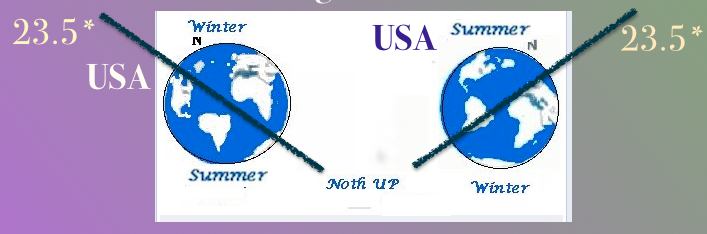
Our Old 23.5 degrees Spin of the Earth in its Orbit
As of December 21, 2017 we are now at 23.4 Degrees.
Children ran to their parents at 5 am saying they thought that T-Rex had walked by. Parents thought the light meant they had overslept. The comet which had passed the Ring Nebula two years
previous, passed merrily on its way. No more was ever heard about the comet of 2008.
The Ring Nebula seemed to have exploded and had become a nebula called the Tree of the Beautiful
Rose when the comet passed that star that became a Nebula and picked up all the debris from that
star making the Sovereign Serpent more spectacular as his first visit to earth. All the metals and
fireballs met the comet head-on and created the most spectacular serpent in the sky. Orion became
the Tree of the Warrior when the comet dropped some of that debris. It was at the time the sky was
in a turmoil.
There are building with three points of sighting the present sun: during recurring Spring Equinox,
the Fall Equinox and the Winter Solstice. Each had its own celebration.
There are also similar buildings that tell us that they used to do the same sightings but no longer
are usable to mark the passages of the sun. That should tell us, that there had been a definite
change in the spin of the earth. . . . not the orbit, which cannot be changed,. . . . . .but the spin
that lengthened
the days and nights forever, . . . . or a least until the next comet changes our
atmosphere and climate locations. Just like now we are having the very same problem with climate
change. And melting ice caps, north, and south. Has our north pole shifted again? Yes, but not very
much. It was 23.5 degrees spin but now it is 23.4 degrees to earth's spin. [ Vonasek, Janelle (2017,
Dec. 21) in the Grand Forks Herald] Does one/tenth of a degree change our climate. I don't know.
What I do know is: not only that the Solstices, Equinox, have changed their time from March 31 and
October 31. Both are at least a week earlier and later No celebrations are created except at Christmas
and at Easter. We now depend on the computer to tell us when each will occur. Many people do not
see the stars anymore. The 10 o’clock newscast is much more interesting.
Half-buried in texts with strange numbers attached to it, and ignored as serious data for
centuries is the 1500’s, Diego de Landa made his first suggestions to change
the Maya/Aztec calendar systems by adding 0-POPP, but it was not implemented until 1584 by
a Papal edict of Rome. EL Obispo de la Ciudad de Mexico, bowed out of his clerical prestigious position in the 1700’s, He mentioned another researcher from an earlier date, who thought the calendars were really so obtuse that no one could ever read them properly again.
It is true th e calendar can never really be straightened out, but before we close the books on the
calendar, one should at least learn what the Maya people said about their Calendar system. It seems
we are telling them what we know, but never seem to accept what they have known for centuries.
It seems this is what the Distance numbers are doing to the Maya Calendar system. The original date is in glyphs for the church version while the Distance number is the same date were written according to Maya older dating systems. Sylvanus Morley, in his third edition of the "Ancient Maya" on pages 229-230. The Maya priests wrote their own solution. One thing that the Maya informant told him was:
"Let us permit our calendar year to gain on the true year as fast as it will. We will allow our calendar to function without change, but when we erect a monument, we will engrave upon it, in addition to the official calendar date of its dedication, a calendar correction for that particular date. In this way, no matter what month our calendar may register, we shall always know, whenever we erect a monument, the position of its corresponding date in the true year"
As for the Distance numbers, it did not surprise me at all. The Maya have just as much intelligence as
those educated in the modern world. It is a good thing to know.
Once upon a time, many years ago, I found a National Geographic with an article about
Chaco Canyon and a book by Frank Waters (6th edition, 1972) who described the city of
150 rooms called Betatakin. The whole structure was built within a cave by the Fire Clan members of the Hopi about 1242 AD and 1300 AD during the time of the Long Drought.
The Hopi did not use wheels. The climb up the single log ladders used to reach various
levels of the canyon wall, either from below to the caves or above them to the mesa's
flat area for farming. Baskets were balanced on their heads because there were times that
going up a log ladder, hands were necessary to use.
The geological history noted the canyons found in the desert areas had been “carved from “sea water,” same as water-eroded pillars of rock in the North Atlantic Ocean; i.e.:yhe Natural Bridge in the desert of Arizona and another granite version in the North Atlantic Ocean.
The flat-topped mesas of the deserts with steep twisting eroded channels. Showed
great wave patterns as the waters rushed against them. Although many canyons were
along the Colorado River, there were many twisted areas
around the mesa structures that were far from any river source. Yet, the logs necessary for construction of the tall apartment type homes and the prayer kivas situated within the large cave areas were never dragged across the land from Kisiwu Springs.
The village was thought to only be accessible through a sort-of tunnel which could never have
been used to move the heavy roof timbers used for building the cave city.
Nor would they have been moved up the canyon wall beneath the cave. Block
and tackle would have been necessary for such an effort.
By the time, the Hopi decided to protect themselves, from unknown dangers using the
caves in the mesa areas it was said that the water around their bases was gone. The
mystery is how the logs arrived at their destination from such great distances both
horizontal and vertical. Maybe the water was there when the Cave Kivas were built.
And logs had been floated to the cave systems. All is unknown because of the following
information recorded by the Conquistadores:
History tells us that in February 1540 Francisco Vásquez de Coronado was the first white
man to find the mesa and their cave/community homes and kivas. With his
group, he brought 15 or more horses, together with burros burdened with their
European necessities and sheep for eating along with their ‘search for “gold.”
Construction continued for three hundred years, until about AD 1150, when the
area was abruptly abandoned.
The Conquistadores insisted that the Hopi, now slaves, had to move the great logs over 50 miles or more for the churches that had to be built for them. They complied by dragging them over the ground, but the natives revolted eventually and killed both soldiers and priests in four different areas of the Mesa villages.
Construction continued for three hundred years, until about AD 1150, when the area
was abruptly abandoned. It's not completely clear why the people left Chaco Canyon,
but the prolonged drought is one possible explanation.
It's not completely clear why the people left Chaco Canyon, but the prolonged drought was
one possible explanation. Because many areas along the west coast of the Americas
was abandoned in the XIIth century without any notice, it probably had the very same
cause. During that century, the end of the Crusades in the Middle East was gearing up
for a final battle or a treaty of some sort with Saladin, and the Prussian King Frederick.
Saladin’s colonies, wherever they were, were required to send a man for the amount
of money earned in the colony----when it reached a certain amount----the area was to
send one man for Saladin’s army.
Along the west coast of the Americas, there was placer mining for gold. The value far
over-valued even silks, sail cloths, leathers, swords, shield makers, etc. On the scale of
how much income was created, the larger colonies had no problem sending a few men,
but the smalller ones earning more income had to send all their eligible men.
In Aztec lands, the Elders rewrote the Hstories and the “Books of Destinos” before they
died off. Once the Elders no longer could farm the land with the women, each colony drifted apart
over a year or two. Were the Arabs in the area. Most certainly they were. But that is
a thread that has to be dropped at this point.
The conclusion that must be questioned seriously: are the dates set down by the
geologists before any valid modern mechanism was available. The Native records
have been ignored as myth and fairy tales.
So what is known is that a comet fell ages ago, had produced a flood which carried
the sea creatures over the tallest mountains in Mesoamerica. The Popol Vuh tells the
story pretty well, but the myth of the Twins, who were supposedly gods, not a twin
comet, one of the day and the other of the night, muddied the traditional histories.
A proof was covered up by Earthquake that destroyed homes, flattened the Maya
during the 1911 comet. The Iridium layer of ash that burned all things, both in Russa
and earlier in Mesoamerica have never been compared with the “native” stories of the
Maya nor of the Aztecs.
This was a time when the “educated”----government or elites----of Mesoamerica had
been forwarned but felt their homes were safe enough since they were obviously building
with stones and mortar, instead of rushes and mud as the lower classes had been.
The lower classes took their animals and what they assumed would be enough food for
a short spell to the caves with the astronomers. The advice given by the star-gazers was
to seal up the entrances just in case there would be unexpected events that they could
not predict. They felt the events might be more serious than past comet activities.
What was recorded was Seven Macaw died by the Hands of the Twins [in a separate
story] when the Sovereign Serpent created the New World after his arrival, then he too
disappeared over the eastern horizon.
It is so easy to doubt “native” history. However, it has been proven that the
History Dancers of the Maya were accurate about the stars. It is worth the time
spent looking at their back racks and find out just what they represented.